Executive Summary
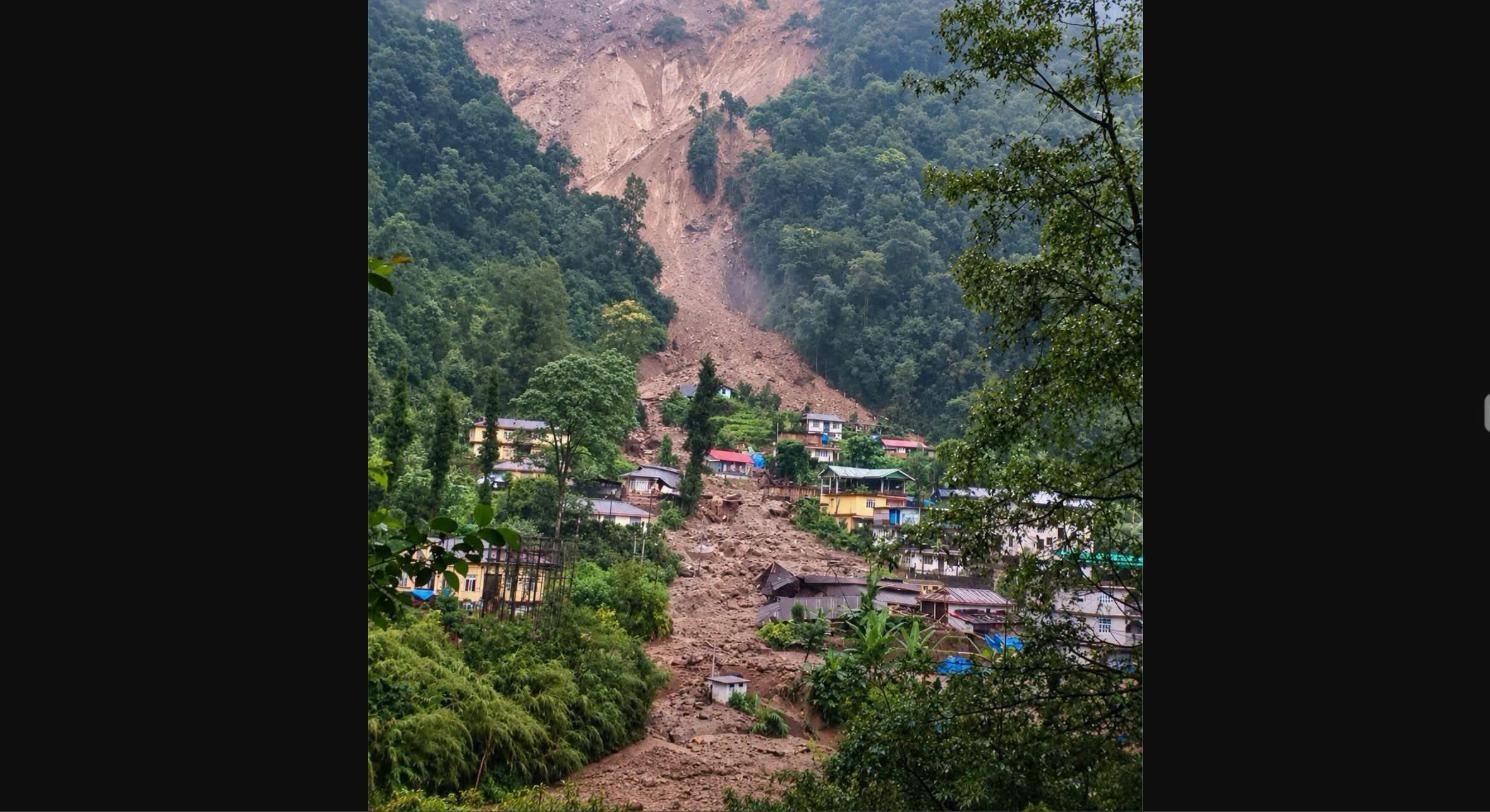
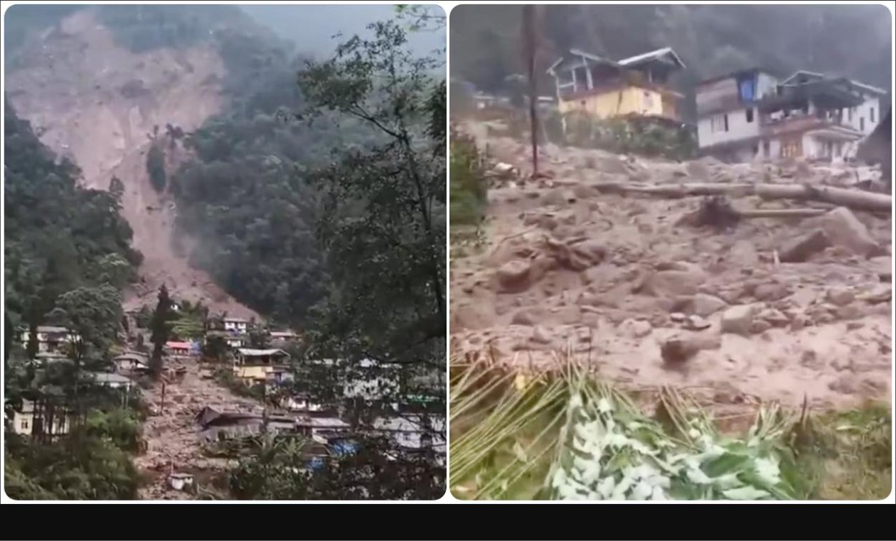
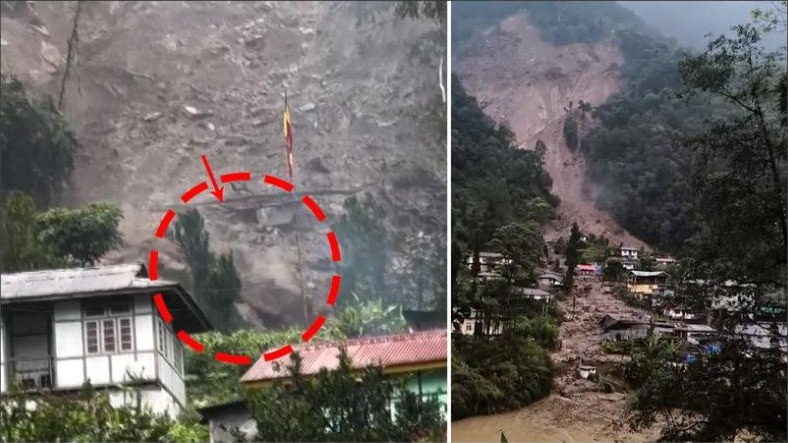
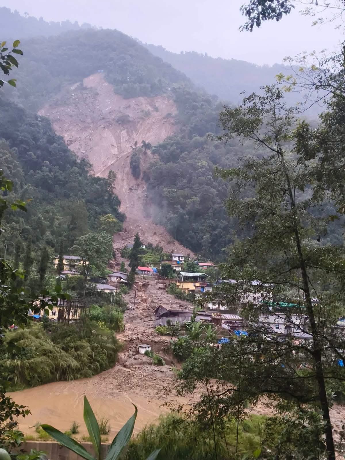
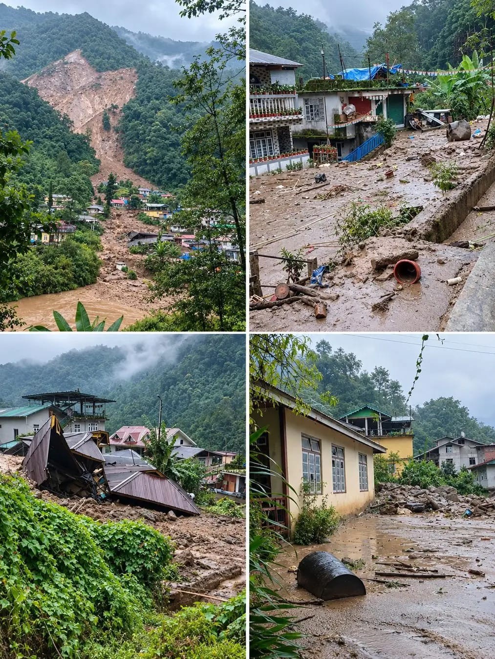
On the night of 24 September 2026, following continuous and intense rainfall — recorded at approximately 224.6 mm in 24 hours in the area — a major landslide occurred above Rimbi village in the Yuksom-Tashiding constituency of Gyalshing district, West Sikkim. A stream channel carrying debris from an earlier landslide at upstream Singlitam is understood to have been diverted toward Rimbi, sending a fast-moving mass of mud, rock and boulders into the settlement. The residential colony of the Rimbi small hydropower project was reported to have been completely swept away, and more than 30 houses in Rimbi — along with government quarters — were damaged or destroyed. A further 5–9 houses in the adjoining Singlitam ward were evacuated as a precaution amid concern that repeated upstream landslides had destabilised the ground beneath Rimbi.
No human casualties have been reported as of the reporting cut-off. Approximately 107 residents were relocated to a relief camp at the Gram Prasadan Kendra, with additional families sheltering with relatives owing to limited camp capacity. The Sikkim government, through the Disaster Relief Commissioner, has begun on-site inspection, and Chief Minister Prem Singh Tamang has stated that resident safety remains the government's foremost priority. Immediate relief of ₹1.3 lakh per destroyed house has been announced, along with a commitment to provide alternative plots and housing under the Sikkim Housing Scheme for households that have lost land, and reconstruction assistance for households retaining usable land.
This assessment finds that the Rimbi landslide is best understood not as an isolated event but as the latest expression of a slope-destabilisation sequence that has affected the Rimbi–Singlitam belt intermittently since August 2026. Contributing factors identified include geologically young and fragile Himalayan terrain, road-widening and hill-cutting works, levelling for public infrastructure, sand mining in the Rimbi River, nearby quarrying and blasting activity, and a proposed small hydroelectric project in the vicinity — compounded by an intense and sustained rainfall event. Village residents and the Rimbi Panchayat have raised the question of whether Rimbi remains safely habitable in its present form, and have called for a permanent resettlement and slope-stabilisation plan rather than temporary relief alone.
SkyMantra GeoIntelligence recommends that state authorities commission a post-monsoon geotechnical and geological hazard assessment of the Rimbi–Singlitam slope system before any reconstruction is approved on the affected footprint, and that immediate relief be paired with a transparent, community-consulted relocation and land-use plan for households in high-residual-risk zones.
1. Introduction and Assessment Approach
1.1 Background
Rimbi is a village in the Yuksom-Tashiding constituency of Gyalshing district (formerly West Sikkim district), located along the Rimbi River in the mountainous terrain of western Sikkim. The area has experienced a series of landslides through the 2026 monsoon season, with the Rimbi Panchayat reporting recurrent slope failures in Rimbi and the neighbouring Singlitam ward since August 2026. This report addresses the significant landslide event of 24–26 September 2026, which caused the most extensive damage recorded in the sequence to date.
1.2 Disaster Overview
Heavy and sustained rainfall over 24–25 September 2026 (approximately 224.6 mm in 24 hours) is understood to have triggered a slope failure above Singlitam that mobilised debris into a stream channel. The redirected flow of mud, rock and boulders travelled downslope into Rimbi village during the night of 24 September, striking the residential colony of the Rimbi small hydropower project — reported completely swept away — and damaging or destroying over 30 houses and government quarters in Rimbi itself. On 25–26 September, continuing concern over ground stability beneath Rimbi, linked to the earlier Singlitam failures, led to the precautionary evacuation of a further 5–9 houses in Singlitam. Local road connectivity in the belt was disrupted by debris.
1.3 Objectives and Intended Uses
- Consolidate available evidence on the extent of the landslide and its effects on people, housing and infrastructure.
- Provide an indicative, early estimate of households and population affected or displaced.
- Summarise immediate relief measures announced and identify priority early and longer-term recovery needs.
- Flag contributing hazard factors and residual risk to inform site-safety decisions ahead of any reconstruction.
- Support situational awareness for district and state authorities, response partners and the affected community.
1.4 Geographic and Sectoral Coverage
This assessment covers Rimbi village and the adjoining Singlitam ward, Yuksom-Tashiding constituency, Gyalshing district, West Sikkim. It addresses housing and household effects, local infrastructure and connectivity, the Rimbi hydropower project colony, and cross-cutting geohazard and environmental considerations. It does not extend to a full district-wide assessment of Gyalshing.
1.5 Data Sources and Collection Methods
This assessment draws on statements and figures issued by the Sikkim district administration and the Office of the Disaster Relief Commissioner, statements attributed to the Rimbi Panchayat leadership and residents, and reporting independently corroborated across multiple news sources current to 26 September 2026. It has not been possible, within the rapid-assessment timeframe, to conduct independent field verification or asset-level structural inspection; SkyMantra GeoIntelligence recommends such verification, supported by satellite and drone imagery analysis of the debris footprint, as a priority next step (Section 5.3).
1.6 Reporting Cut-off
This report reflects information available up to 26 September 2026. Information received after this date is not reflected unless the report is subsequently revised.
1.7 Limitations and Interpretation
- Household, population and damage figures are early estimates drawn from official and media statements, not a verified asset-level survey.
- A precise, geologically attributed causal analysis (rainfall-triggered vs. anthropogenic slope disturbance) requires a dedicated post-monsoon geotechnical study.
- Monetary damage and recovery-cost figures are indicative only; official relief amounts (₹1.3 lakh per destroyed house) are cited from government announcements and are not construed here as a full recovery-cost estimate.
- Zero or blank entries in tables indicate that no reliable figure was available at the time of writing, not that no effect occurred.
2. Pre-Disaster Context and Risk Profile
2.1 Geographic and Environmental Setting
Rimbi lies within the geologically young and tectonically active Lesser and Higher Himalayan terrain of West Sikkim, characterised by steep slopes, high relief, deeply incised river valleys and highly erodible, fractured rock and colluvial soil. The Rimbi River, a tributary system within the wider Rangit basin, runs through the village. Such terrain is inherently prone to slope failure during the monsoon, and susceptibility is heightened where slope toe support is removed or slope loading is increased by human activity.
2.2 Settlement and Land Use
Rimbi and Singlitam are rural settlements with a mix of private residential housing, government staff quarters, and the residential colony associated with the Rimbi small hydropower project. Livelihoods in the belt are predominantly agrarian, supplemented by tourism-linked activity typical of the Yuksom-Tashiding corridor, a gateway area for trekking and pilgrimage tourism in West Sikkim.
2.3 Contributing and Compounding Hazard Factors
Multiple contributing factors to slope destabilisation in the Rimbi–Singlitam belt have been identified by residents, local officials and independent reporting:
- An intense rainfall event (~224.6 mm in 24 hours) saturating already unstable slopes.
- A precursor landslide upstream at Singlitam that diverted a stream channel and mobilised additional debris toward Rimbi.
- Road construction and hill-cutting using heavy machinery in the vicinity.
- Levelling and earthworks associated with public infrastructure (including a playground) on the hillside.
- Sand mining within the Rimbi River bed, reducing bank and slope stability.
- Stone quarrying and blasting activity in the surrounding area.
- A proposed small-scale hydroelectric project in the vicinity, cited by residents as a further pressure on slope stability.
Taken together, these factors describe a compound and cascading hazard sequence: an initial slope failure at Singlitam, amplified by anthropogenic slope disturbance and channel modification, cascaded into a second, more damaging debris flow at Rimbi within the same rainfall event window.
3. Disaster Effects and Impact Summary
3.1 Affected Population and Human Impacts
| Indicator | Estimate | Notes |
|---|---|---|
| Houses damaged/destroyed — Rimbi | 32+ | Includes government staff quarters |
| Rimbi hydropower project colony | Fully swept away | Residential colony of the small hydropower project |
| Houses evacuated (precautionary) — Singlitam | 5–9 | Ground-stability concern beneath Rimbi |
| Residents relocated to relief camp | ≈107 | Gram Prasadan Kendra relief camp |
| Human casualties | 0 reported | As of 26 September 2026 |
| Livestock | Displaced/lost (unquantified) | Reported qualitatively; no verified count |
| Local roads | Disrupted | Blocked/damaged by debris deposition |
These figures are drawn from district administration and media statements current to 26 September 2026 and represent an early, consolidated picture rather than a verified census of affected households.
3.2 Displacement and Shelter
Displaced households have been accommodated through a combination of the Gram Prasadan Kendra relief camp, the Rimbi Panchayat House, and informal arrangements with relatives, reflecting limited formal shelter capacity relative to the number of households displaced. Continued monitoring of shelter adequacy — covered space, water, sanitation and privacy — is recommended given the number of families involved.
3.3 Service and Livelihood Disruption
- Local road connectivity within the Rimbi–Singlitam belt disrupted by debris deposition.
- Loss of housing and, for hydropower-colony residents, workplace-linked accommodation.
- Agricultural land and livestock holdings in the debris path likely affected, though not yet separately quantified.
- Potential disruption to the Rimbi small hydropower facility's operating workforce accommodation, with possible knock-on implications for local power supply continuity (requires verification).
3.4 Summary Assessment of Effects
The event is assessed as a moderate-to-significant localised disaster in human and housing terms — with no loss of life but substantial loss of housing and displacement relative to the size of the settlement — set against a backdrop of recurring hazard activity that elevates the residual risk of further damage during the remainder of the monsoon season and in future rainfall events.
Photographic Documentation
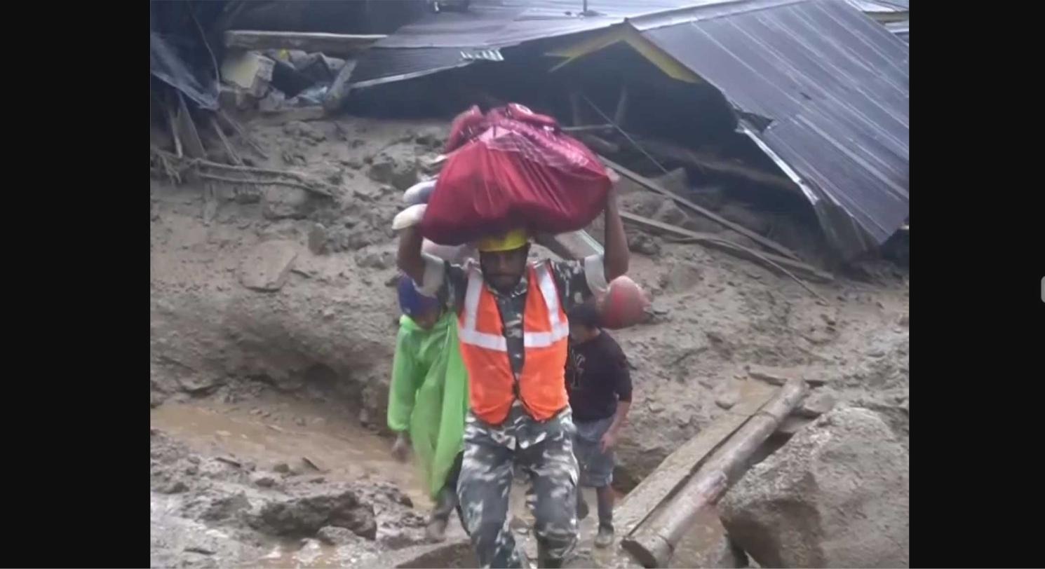
The images below are field/video-grab photographs of the 24–26 September 2026 Rimbi landslide, gathered from independent news sources and community-shared material for situational documentation. They are reproduced here for assessment and briefing purposes with source attribution; copyright in each image remains with its original source.
4. Sectoral Findings
4.1 Housing
More than 30 private houses in Rimbi, together with government staff quarters, were damaged or destroyed by the debris flow of 24 September 2026. The residential colony of the Rimbi small hydropower project was reported completely swept away. A further 5–9 houses in Singlitam were evacuated as a precaution following an assessment that repeated upstream landslides may have destabilised the ground beneath Rimbi. The Government of Sikkim has announced immediate financial assistance of ₹1.3 lakh per destroyed house, alternative plots together with housing under the Sikkim Housing Scheme for households that have lost land, and reconstruction assistance for households retaining usable land.
4.2 Infrastructure and Connectivity
Local roads serving Rimbi and Singlitam were disrupted by debris deposition, affecting access for both residents and responding agencies. No verified information is yet available on damage to water supply, electricity distribution or telecommunication infrastructure in the immediate footprint; SkyMantra GeoIntelligence recommends this be confirmed through ground verification as a priority, given the presence of the hydropower facility in the affected area.
4.3 Livelihoods and Productive Assets
Rimbi's economy is predominantly agrarian with tourism-linked activity associated with the Yuksom-Tashiding corridor. Livestock displacement has been reported qualitatively; agricultural land within or adjoining the debris path is likely to have sustained damage that has not yet been separately quantified. Loss of housing for hydropower-colony staff may also have a livelihood dimension for affected employees.
4.4 Geohazard, Environment and Cross-Cutting Risk
The Rimbi event should be read as part of a wider slope-destabilisation sequence in the belt since August 2026, rather than as an isolated occurrence. Contributing factors span natural geological fragility and an intense rainfall trigger, together with anthropogenic pressures (road-cutting, levelling works, river-sand mining, quarrying/blasting, and a proposed small hydro project) that reduce slope and channel stability. The Disaster Relief Commissioner has indicated that a detailed geological assessment of the belt is planned once the monsoon season concludes. Until this assessment is available and a hazard-zonation map is produced, residual risk to any structure retained or rebuilt on the existing footprint should be treated as elevated.
4.5 Governance and Community Perspective
The Rimbi Panchayat President has confirmed that landslides have recurred in Rimbi and Singlitam wards since August 2026. Affected residents have called for a permanent settlement plan that secures their long-term future, rather than temporary relief alone — a position consistent with the scale and recurrence of the hazard documented in this report.
5. Response, Recovery Needs and Recommendations
5.1 Response to Date
- District administration and the Sikkim government arranged emergency shelter for displaced families.
- The Disaster Relief Commissioner conducted an on-site inspection of the affected area on 25 September 2026.
- Chief Minister Prem Singh Tamang publicly affirmed resident safety and well-being as the government's foremost priority.
- Immediate financial relief of ₹1.3 lakh per destroyed house has been announced.
- Provision of alternative plots and housing under the Sikkim Housing Scheme has been committed for households that have lost land; reconstruction assistance has been committed for households retaining usable land.
5.2 Priority Early Recovery Needs (0–6 months)
- Complete a household-level verification survey of all damaged/destroyed structures and displaced families to confirm eligibility for announced relief.
- Ensure relief-camp and host-family arrangements meet minimum standards for shelter, water, sanitation and privacy for the duration of displacement.
- Undertake a rapid geotechnical inspection of the Rimbi–Singlitam slope and stream channel to identify any imminent secondary-failure risk before families are permitted to return to or near the debris footprint.
- Clear and stabilise debris-blocked local roads to restore access for residents and relief operations.
- Verify the operational status of the Rimbi small hydropower facility and any associated safety or supply implications.
5.3 Longer-Term Recovery and Risk Reduction (6+ months)
- Commission the planned post-monsoon geological and geotechnical hazard assessment of the Rimbi–Singlitam belt, including hazard zonation, before approving reconstruction on the existing footprint.
- Develop a transparent, community-consulted relocation and resettlement plan for households in confirmed high-residual-risk zones, addressing the Panchayat's and residents' call for a permanent settlement solution.
- Review and regulate slope-disturbing activities in the vicinity — hill-cutting for roads, hillside levelling for public infrastructure, river-sand mining and quarrying/blasting — as part of any reconstruction and land-use plan.
- Reassess the siting and design safeguards for any proposed small hydroelectric development in the vicinity in light of demonstrated slope instability.
- Strengthen early-warning and slope-monitoring arrangements for the wider West Sikkim landslide-prone corridor, given the recurrence of events in this belt since August 2026.
5.4 Further Assessment and Way Forward
SkyMantra GeoIntelligence recommends that this rapid assessment be followed, at the earliest opportunity, by (i) high-resolution satellite and drone-based mapping of the debris footprint and any residual instability, (ii) a ground-verified Detailed Damage Assessment of housing, infrastructure and productive assets, and (iii) the geological hazard assessment already indicated by the Disaster Relief Commissioner. SkyMantra GeoIntelligence is available to support state and district authorities with satellite-based change detection, terrain and slope-hazard modelling, and geospatial monitoring of the affected corridor.
6. Conclusion
The 24–26 September 2026 landslide at Rimbi, West Sikkim, caused significant, fortunately non-fatal, damage to housing and displacement of over a hundred residents, and fits within a recognised pattern of recurring slope failure in the Rimbi–Singlitam belt since August 2026. Immediate relief measures announced by the Government of Sikkim are a necessary first step. Durable safety for the community, however, depends on a credible geotechnical hazard assessment, regulation of slope-disturbing development activity in the vicinity, and a resettlement plan developed in consultation with the affected community, as residents themselves have requested. SkyMantra GeoIntelligence will continue to monitor the site through satellite observation and update this assessment as verified information becomes available.
Video Coverage and Additional Sources
Independently published and community-shared video footage of the landslide and its aftermath, useful for briefing and situational review:
- ET Now (YouTube) — "Sikkim Landslide Horror: Massive Rocks & Mudslide Crash Down In Rimbi Amid Heavy Rain"
- India TV News — "Sikkim landslide wreaks havoc after heavy rain, houses destroyed as debris rushes towards village"
- Free Press Journal — "Heavy Rain Damages Houses In Rimbi Village As Landslides, Mudflows And Road Blockages Hit Gangtok"
- India.com — "Fresh landslide sweeps away houses, trees in Sikkim's Rimbi village — Dramatic visuals"
- NewsBytes — "Continuous rainfall triggers massive landslide in Sikkim"
Sources
- Down To Earth — "Will the village survive? Question that haunts everyone after landslide at Rimbi in West Sikkim" (downtoearth.org.in)
- EastMojo — "Sikkim: Rimbi may be uninhabitable after recurring landslides" (eastmojo.com)
- ANI — "Families shift to safer locations as landslide damages over 32 houses, govt quarters in Sikkim's Rimbi" (aninews.in)
- Shafaqna India — "Heavy Rain Triggers Landslide in Sikkim's Rimbi, Damaging Several Houses" (india.shafaqna.com)
- Northeast News — "Heavy rain triggers landslide in Sikkim's Rimbi, residents fear further damage" and "Rimbi landslides: 107 evacuated as West Sikkim village faces fresh threat" (nenews.in)
- The News Mill — "Heavy rainfall triggers landslide, damages over 32 houses in Sikkim's Rimbi village" and "Major landslide damages homes in Sikkim's Rimbi village; no casualties" (thenewsmill.com)
- The Tribune — "Torrential rain, landslide wreaks havoc in Sikkim's Rimbi; several houses damaged" (tribuneindia.com)
- India.com — "Watch: Fresh landslide sweeps away houses, trees in Sikkim's Rimbi village" (india.com)