Executive Summary
From late August through September 2026, sustained and heavy monsoon rainfall concentrated in the catchments of Nepal, north Bihar and neighbouring states drove the Ganga and its major tributaries — the Kosi, Gandak, Burhi Gandak, Punpun, Bagmati and Ghaghra — to dangerous and, in several places, unprecedented levels. Between 5 and 9 September 2026, the Ganga simultaneously broke all-time high-water-level records at three gauging stations: Gandhi Ghat in Patna (50.57 m, exceeding the August 2016 record by 5 cm), Pandarak in Patna (43.92 m, exceeding the August 2021 record by 19 cm), and Sultanganj in Bhagalpur (36.78 m, exceeding the August 2021 record by 3 cm). Flows were compounded by cascading discharge from Nepal's catastrophic 26 August 2026 Rasuwa–Bhotekoshi ice-and-rock avalanche and flood event, whose debris-laden waters entered the Bihar river system via the Gandak, Bagmati and Kosi basins.
The number of people affected rose through the month as more gram panchayats reported inundation: from an estimated 22 lakh (2.2 million) in the first week of September, to over 40 lakh by 8–9 September, to a consolidated 50.49 lakh (approximately 5.05 million) people across 576 gram panchayats in 88 blocks of 15 districts by 23 September — the most recent official figure ahead of this report's cut-off. The 15 affected districts are Patna, Bhojpur, Saran, Vaishali, Bhagalpur, Begusarai, Buxar, Samastipur, Munger, Katihar, Lakhisarai, Khagaria, Purnea, Madhepura and Araria/Arwal (district lists vary slightly across official bulletins). At least 5 deaths by drowning were confirmed in the Patna district area (Danapur and Maner) in the first week of September, with a further 10 people rescued after a boat capsized near Raghopur Diara; casualty figures had not been comprehensively updated as of this report's cut-off and should be treated as a minimum, not a final count.
Notably, the severity of flooding occurred despite Bihar recording an overall seasonal rainfall deficit of 28–35 per cent. Analysts attribute this apparent paradox to rainfall being concentrated in intense late-monsoon spells over already-saturated catchments, reduced river conveyance capacity from decades of siltation, degraded upstream catchments, backwater effects from the Farakka Barrage, multiple embankment breaches, and cascading discharge from the Nepal disaster upstream. Infrastructure impacts included diversion of the Patna–Gaya railway line, severed road connectivity at Mokama, Athmalgola, Fatuha and Bakhtiyarpur, and embankment breaches including a 20-metre breach on the Mahi River in Saran district and a breach on the Daha River near Imadpur. Extensive standing-crop losses (paddy, maize and fodder) were reported across the affected districts.
The State Disaster Management Department, SDRF, NDRF and district administrations mounted a large-scale relief response, deploying up to 37 response teams, nearly 2,000 boats at the peak of the crisis, and operating relief camps and community kitchens serving crores of meals. SkyMantra GeoIntelligence recommends that recovery planning explicitly address the compounding role of upstream catchment degradation and cross-border cascading hazards, and that embankment integrity and Farakka backwater management be reviewed ahead of future monsoon seasons.
1. Introduction and Assessment Approach
1.1 Background
Bihar's low-lying, alluvial plains and dense network of Himalayan-fed rivers — the Ganga, Kosi, Gandak, Burhi Gandak, Bagmati, Punpun and Ghaghra among them — make it one of India's most flood-prone states, with recurrent monsoon flooding an almost annual occurrence. The 2026 flood season was distinguished by the scale and, at several gauging stations, the unprecedented severity of river levels, compounded by cascading flows from a major glacial-lake/rock-avalanche disaster in Nepal in late August 2026.
1.2 Disaster Overview
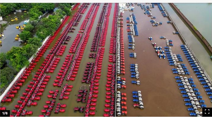
Heavy monsoon rainfall through July and August, concentrated over already-saturated catchments in Nepal, north Bihar and neighbouring Indian states, combined with the 26 August 2026 Rasuwa–Bhotekoshi ice-and-rock avalanche and flood event in Nepal, drove the Ganga and its tributaries to record and near-record levels through early-to-mid September 2026. The Ganga broke all-time high-water-level records simultaneously at three stations — Gandhi Ghat (Patna), Pandarak (Patna) and Sultanganj (Bhagalpur) — between 5 and 9 September. The flood situation subsequently spread and persisted through September as water moved downstream and additional gram panchayats reported inundation, with the state's consolidated affected-population figure rising from roughly 22 lakh in early September to over 50 lakh by 23 September.
1.3 Objectives and Intended Uses
- Consolidate available evidence on the extent, scale and evolution of the 2026 Bihar floods across affected districts.
- Provide a consolidated, dated picture of the population, housing, agricultural and infrastructure effects reported to date.
- Summarise relief measures undertaken and identify priority early and longer-term recovery needs.
- Flag contributing hazard factors — including catchment degradation and cross-border cascading risk — relevant to future flood-risk reduction.
- Support situational awareness for state and district authorities, response partners and affected communities.
1.4 Geographic and Sectoral Coverage
This assessment covers the 15 districts of Bihar most consistently reported as affected in official bulletins through September 2026: Patna, Bhojpur, Saran, Vaishali, Bhagalpur, Begusarai, Buxar, Samastipur, Munger, Katihar, Lakhisarai, Khagaria, Purnea, Madhepura and Araria/Arwal. It addresses population and housing effects, agriculture and livelihoods, infrastructure and connectivity, and cross-cutting hazard and environmental factors. District lists vary slightly between successive official bulletins; this report uses the most frequently cited 15-district set.
1.5 Data Sources and Collection Methods
This assessment draws on successive bulletins from the Bihar State Disaster Management Department reported via national and regional media between early and late September 2026, Central Water Commission-linked flood-level reporting, and independent news reporting corroborated across multiple sources. Given the fast-moving nature of the flood bulletins, figures for people affected, relief camps and resources deployed reflect a series of point-in-time snapshots rather than a single consolidated verified survey; the most recent figure available as of the reporting cut-off is used as the headline estimate in each case, with the evolution over time noted where relevant. SkyMantra GeoIntelligence recommends satellite- and drone-based flood-extent mapping to independently verify the inundation footprint and cross-check reported population figures.
1.6 Reporting Cut-off
This report reflects information available up to 26 September 2026, drawing on the most recent consolidated official figures available as of 23 September 2026. Information received after this date is not reflected unless the report is subsequently revised.
1.7 Limitations and Interpretation
- Affected-population, casualty and damage figures are drawn from successive official and media bulletins issued over several weeks and are not a single verified census; later bulletins generally supersede earlier ones as coverage improved.
- District lists cited across sources show minor inconsistencies (e.g., Araria vs. Arwal); this report follows the most frequently repeated 15-district list.
- Casualty figures (at least 5 confirmed deaths as of early September) have not been comprehensively updated in available sources through the reporting cut-off and should be treated as a floor, not a final count.
- Crop, livestock and infrastructure damage figures cited are illustrative and drawn from spot reporting rather than a completed district-wise damage survey.
- Zero or blank entries in tables indicate that no reliable figure was available at the time of writing, not that no effect occurred.
2. Pre-Disaster Context and Risk Profile
2.1 Geographic and Environmental Setting
Bihar sits on the flat, low-gradient alluvial plain of the Ganga basin, fed by a dense network of Himalayan snow- and rain-fed rivers that carry high sediment loads and are prone to channel shifting, bank erosion and overbank flooding. North Bihar in particular lies downstream of steep, geologically young Himalayan catchments in Nepal that generate flashy, sediment-rich runoff. This terrain makes Bihar structurally flood-prone even in years of average or below-average state-wide rainfall, since flows are heavily influenced by upstream catchment conditions in Nepal and neighbouring Indian states rather than by local rainfall alone.
2.2 Settlement and Land Use
The 15 affected districts include Bihar's capital and largest urban centre, Patna, along with a mix of smaller urban centres and predominantly rural, agrarian settlements along the Ganga, Kosi, Gandak and their tributaries. Diara (riverine island and floodplain) settlements, common along these rivers, are especially exposed, as seen in the Raghopur Diara boat-capsize incident. Agriculture — particularly paddy, maize and fodder cultivation on the fertile but flood-exposed floodplains — is a dominant livelihood across the affected belt.
2.3 Contributing and Compounding Hazard Factors
Multiple contributing and compounding factors have been identified by officials and independent analysts for the severity of the 2026 floods, notably that they occurred despite an overall seasonal rainfall deficit of 28–35 per cent in Bihar itself:
- Rainfall concentrated in intense late-monsoon spells (July–August) over already-saturated soils, converting a larger share of rainfall directly into runoff.
- Cascading discharge from Nepal's 26 August 2026 Rasuwa–Bhotekoshi ice-and-rock avalanche and flood disaster, entering Bihar's river systems via the Gandak, Bagmati and Kosi catchments.
- Decades of siltation raising riverbed levels and reducing channel conveyance capacity in the Ganga and its tributaries.
- Degraded upstream catchments, including deforestation, reducing natural water absorption and increasing surface runoff.
- Backwater effects from the Farakka Barrage downstream, impeding drainage of Ganga floodwaters through Bihar.
- Multiple embankment breaches, including on the Mahi River (Saran) and Daha River (near Imadpur), releasing floodwaters into previously protected areas.
- Unplanned urbanisation and drainage congestion in urban centres including Patna, worsening waterlogging on top of riverine flooding.
Taken together, these factors describe a flood event driven substantially by upstream and structural conditions — catchment degradation, embankment integrity, cross-border cascading flows and downstream barrage effects — rather than by Bihar's own seasonal rainfall alone, which explains the apparent paradox of severe flooding in a rainfall-deficit year.
3. Disaster Effects and Impact Summary
3.1 Affected Population and Human Impacts
| Indicator | Estimate | Notes |
|---|---|---|
| People affected (consolidated, 23 Sep) | ≈50.49 lakh (~5.05 million) | Across 576 gram panchayats, 88 blocks, 15 districts |
| Districts affected | 15 | Patna, Bhojpur, Saran, Vaishali, Bhagalpur, Begusarai, Buxar, Samastipur, Munger, Katihar, Lakhisarai, Khagaria, Purnea, Madhepura, Araria/Arwal |
| Confirmed deaths | 5+ (early Sept, not comprehensively updated) | 2 Danapur, 3 Maner (Patna district), by drowning |
| Boat-capsize rescue | 10 rescued | Near Raghopur Diara, 8 September |
| Ganga record levels | 3 gauges broke all-time highs | Gandhi Ghat, Pandarak (Patna); Sultanganj (Bhagalpur), 5–9 September |
| Relief camp population | ≈7,700–13,450 (varies by bulletin) | 6–15 relief camps operating at different points in September |
| Rainfall context | 28–35% seasonal deficit statewide | Flooding driven by upstream/catchment factors, not local rainfall |
These figures are consolidated from successive official and media bulletins issued through September 2026 and represent the most recent snapshot available as of the reporting cut-off, not a single point-in-time verified census.
3.2 Displacement and Shelter
Displaced households have been accommodated through a network of relief camps (numbering between 6 and 15 at different points in September, housing between roughly 7,700 and 13,450 people) and community kitchens (reported variously between 723 and nearly 1,979 operating at peak, serving crores of meals cumulatively), alongside informal arrangements with relatives and host communities. The scale of camp populations relative to the total affected population (over 5 million) indicates that the large majority of affected households remained in or near their own communities, often in partially flooded conditions, rather than in formal relief camps.
3.3 Service and Livelihood Disruption
- Patna–Gaya railway line diverted due to high water levels affecting the bridge crossing.
- Road connectivity severed at Mokama, Athmalgola, Fatuha and Bakhtiyarpur, among other locations.
- Extensive standing-crop losses (paddy, maize, fodder) reported across affected districts, with over 1,000 acres destroyed in individual villages cited as illustrative examples.
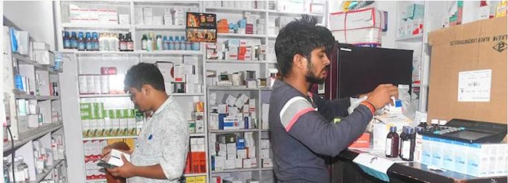
- Urban waterlogging and flooding of homes, shops, medical stores and other establishments reported in Patna and other urban centres.
- Livestock losses and fodder shortages reported, with over 5,000 quintals of animal fodder distributed in relief operations as of mid-September.
3.4 Summary Assessment of Effects
The 2026 Bihar floods are assessed as a large-scale, multi-district disaster affecting more than 5 million people — among the most significant flood events in the state in recent years by population affected — with confirmed but likely under-reported loss of life, extensive agricultural and infrastructure damage, and a protracted, multi-week timeline driven as much by upstream catchment and structural factors as by local rainfall.
Photographic Documentation
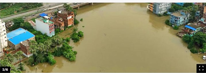
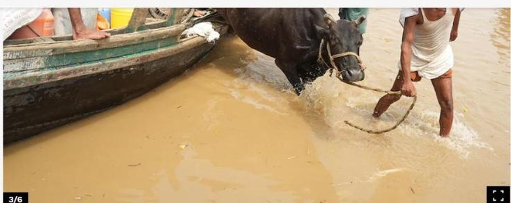
The images below document the September 2026 Bihar floods, gathered from independent news sources for situational documentation. They are reproduced here for assessment and briefing purposes with source attribution; copyright in each image remains with its original source.
4. Sectoral Findings
4.1 Housing and Urban Impacts
Widespread inundation of homes, shops and public buildings was reported across Patna and other affected urban and rural areas, including flooding of medical stores and other establishments in Patna city itself, reflecting both riverine flooding and urban waterlogging. Diara (riverine floodplain) settlements were particularly exposed, with households along the Nakta Diara area near Patna evacuated by boat along with livestock and belongings.
4.2 Agriculture and Livelihoods
Standing crops — principally paddy, maize and fodder — were extensively submerged across the affected districts, with individual villages reporting over 1,000 acres of farmland destroyed. Given that agriculture is the dominant livelihood across Bihar's flood-exposed floodplains, the loss of standing crops so close to harvest represents a significant income and food-security shock for affected households, compounding losses to household assets and, in some cases, dwellings.
4.3 Infrastructure and Connectivity
The Patna–Gaya railway line was diverted owing to high water levels affecting a key bridge crossing, and road connectivity was severed at multiple points including Mokama, Athmalgola, Fatuha and Bakhtiyarpur. Embankment breaches were reported on the Mahi River in Saran district (approximately 20 metres) and on the Daha River near Imadpur, releasing floodwaters into areas previously protected by flood-control infrastructure. SkyMantra GeoIntelligence recommends post-flood structural inspection of all breached and stressed embankments ahead of future monsoon seasons.
4.4 Geohazard, Environment and Cross-Cutting Risk
The 2026 Bihar floods illustrate the compounding role of upstream catchment conditions in downstream flood risk: a severe glacial/rock-avalanche disaster in Nepal on 26 August 2026 contributed cascading discharge into Bihar's river systems within days of a locally rainfall-deficit monsoon season otherwise producing below-normal statewide totals. This underscores that flood risk in north Bihar cannot be assessed from state-level rainfall statistics alone, and that early-warning and flood-forecasting systems need to account for upstream conditions in Nepal and neighbouring states, including glacial and slope-hazard monitoring, as part of an integrated transboundary risk picture.
4.5 Governance and Response Coordination
The Bihar State Disaster Management Department coordinated the state-wide response, issuing successive bulletins as the number of affected panchayats and blocks grew through September. District administrations, SDRF and NDRF teams conducted boat-based evacuation, particularly in diara and riverine settlements. The scale and duration of the event — spanning multiple weeks and 15 districts — highlights the value of a consolidated, cross-district damage and needs assessment to support coherent state-wide recovery prioritisation.
5. Response, Recovery Needs and Recommendations
5.1 Response to Date
- State Disaster Management Department coordinated a multi-week, multi-district response as the flood situation evolved through September 2026.
- Up to 27 SDRF and 8–10 NDRF teams (37 response teams at peak) deployed for rescue and evacuation.
- Up to approximately 1,979 boats deployed at the peak of the crisis for evacuation and relief delivery.
- Between 6 and 15 relief camps operated at different points, housing between roughly 7,700 and 13,450 displaced people.
- Community kitchens (up to nearly 1,979 at peak) served an estimated cumulative total in the crores of meals.
- Relief materials distributed included polythene sheets (up to ≈400,000), dry-ration packets, and thousands of quintals of animal fodder.
5.2 Priority Early Recovery Needs (0–6 months)
- Complete district-wise verification of casualty figures, given that available casualty data has not been comprehensively updated since early September.
- Conduct a systematic, district-wise crop and livestock damage assessment ahead of the rabi sowing season, given the scale of standing-crop losses reported.
- Prioritise structural inspection and repair of breached and stressed embankments (Mahi River, Saran; Daha River, Imadpur; and others) before the next monsoon.
- Restore severed road and rail connectivity at Mokama, Athmalgola, Fatuha, Bakhtiyarpur and the Patna–Gaya rail corridor.
- Continue and, where needed, scale up relief-camp and community-kitchen operations for households whose homes remain uninhabitable.
5.3 Longer-Term Recovery and Risk Reduction (6+ months)
- Commission an integrated review of embankment integrity across the Ganga, Kosi, Gandak and Burhi Gandak systems, informed by the specific breach locations identified in 2026.
- Invest in de-siltation and channel-conveyance restoration for rivers shown to have reduced flood-carrying capacity.
- Strengthen transboundary early-warning arrangements with Nepal, incorporating glacial-lake and slope-hazard monitoring given the demonstrated cascading impact of the August 2026 Rasuwa–Bhotekoshi disaster on Bihar's flood severity.
- Review Farakka Barrage operating and backwater-management protocols in consultation with the relevant central authorities, given their cited role in impeding drainage through Bihar.
- Support catchment restoration (afforestation, erosion control) in upstream areas to reduce runoff intensity into Bihar's rivers.
- Develop or update diara and floodplain settlement guidance, given the particular exposure of riverine-island communities such as Nakta Diara and Raghopur Diara.
5.4 Further Assessment and Way Forward
SkyMantra GeoIntelligence recommends that this rapid assessment be followed by (i) satellite- and drone-based mapping of the peak flood-extent footprint across all 15 affected districts to independently verify the inundation area and cross-check reported population figures, (ii) a ground-verified, district-wise Detailed Damage Assessment of housing, agriculture and infrastructure, and (iii) a transboundary hydrological review examining the contribution of the Nepal Rasuwa–Bhotekoshi event to peak flows in Bihar. SkyMantra GeoIntelligence is available to support state authorities with satellite-based flood-extent mapping, embankment and catchment monitoring, and cross-border hazard-cascade analysis.
6. Conclusion
The 2026 Bihar floods affected over 5 million people across 15 districts and produced record-breaking water levels on the Ganga at three separate gauging stations — a scale of impact made more striking by the fact that it occurred in a season of overall rainfall deficit for the state. The event illustrates that flood risk in north Bihar is driven substantially by factors beyond local rainfall: upstream catchment conditions in Nepal, cascading transboundary hazards, embankment integrity, siltation and downstream barrage effects all played a documented role. Immediate relief operations by the state government, SDRF and NDRF have reached millions of affected people, but the scale of agricultural and infrastructure damage, combined with the demonstrated cross-border cascading risk, points to a need for recovery planning that goes beyond repair-in-place to address the structural and transboundary drivers of the disaster. SkyMantra GeoIntelligence will continue to monitor the situation through satellite observation and update this assessment as verified information becomes available.
Video Coverage and Additional Sources
Independently published video coverage of the 2026 Bihar floods, useful for briefing and situational review:
- Live Cities / Bihar News — "Bihar Flood 2026: Train rad, dam breached, Punpun's havoc in Patna"
- Aaj Tak — "Bihar Flood Alert 2026: Ganga water level rising triggers flood alert"
- News4Nation — "Bihar Flood 2026: Devastation approaching, preparations amid alert"
- News coverage — "Bihar received less than 30% of normal rainfall this year, but is still facing floods"
- News coverage — "Floodwaters swallow streets in 15 districts of Bihar"
- News coverage — "Around 22 lakh lives affected as Ganga, Kosi rivers surge; 12 districts on high alert"
Sources
- Forbes India — "Bihar Floods 2026: Stunning Images from Patna's Worst-Hit Areas" (forbesindia.com)
- The Print — "Bihar flood situation grim as over 46 lakh people affected across 15 districts" (theprint.in)
- National Herald — "Bihar floods affect 50.49 lakh people across 15 districts" (nationalheraldindia.com)
- TechTimes — "Bihar Floods Displace Four Million as Ganga Breaks All-Time High-Water Marks" (techtimes.com)
- The Watchers — "Five dead as Bihar floods affect more than 3.4 million, Ganga exceeds previous highest levels" (watchers.news)
- Vajiram & Ravi — "Bihar Floods 2026, Over 22 Lakh People Affected Across 14 Districts" (vajiramandravi.com)
- Mongabay India — "Floods affect millions in Bihar despite rainfall deficit" (india.mongabay.com)
- Business Standard — "Bihar flood situation grim as over 4.6 million affected across 15 districts" (business-standard.com)